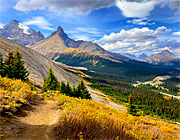


A long day stopping at beautiful lakes, waterfalls and glaciers and making time for an excellent hike up Parker Ridge which slowly reveals spectacular views.
More Canada


From Moraine Lake we headed north up the Icefields Parkway to Jasper. Widely regarded as one of the most scenic roads in the world we set off early as we knew we'd be stopping multiple times to take photographs and also planned to hike up Parkers Ridge.
Our first stop was Bow Lake. It was a bit cloudy but bright and very still so we were set up for some good lake reflections.


The structure in the cliffs plunging into the waters of the lake make for a spectacular location on a calm day.


Our next Stop was Peyto Lake, very different to Bow. At Bow Lake there were only a couple of people strolling the lakeshore. At Peyto there were quite a lot of people gathered on the viewing platform; you are far above the lake and isolated from the landscape, a much more touristy situation. With more time it would be a better experience to hike down to the lakeshore.

Though Peyto is an unbelievable blue, we far preferred Bow Lake.
The turquoise colour is due to the influx of glacial rock "flour", very fine particles created by the grinding of rocks as the glacier moves.


Next up: Waterfowl Lake. Just a short roadside stop but an attractive setting with Mount Cephren rising above it.


Howse Pass Overlook is about ten miles north of Waterfowl Lake and it was one of my favourite spots on the Parkway. Though it's hard to make out the pass itself, there is an expansive view over the North Saskatchewan River, flowing through a wide valley.
There are several very good information boards which give the history of this area.

The river rises in the Saskatchewan Glacier and Native Americans hunted and camped along its shores for thousands of years before European fur traders arrived in the late 1700s.


The traders relied heavily on the knowledge of the indigenous peoples to learn the viable routes across the mountains. David Thompson first led an expedition over Howse Pass in 1807.
The fur trade brought guns and other goods to the Native Americans and less than three years after Thompson's expedition the Piikani Nation blocked the pass to the traders, forcing them to look for other routes.


After hiking the Parker Ridge trail we continued north along the Icefields Parkway making a couple more stops before we reached Jasper.


First Columbia Icefield which is a popular spot. It's the largest area of glacial ice in the Canadian Rockies, 200 sq km. It's also a unique region in North America being a triple watershed, the only place where water flows down to three oceans: the Pacific, the Atlantic, and the Arctic.
It's a bit too touristy for us. We could have done a glacier trek but we didn't think it could match what we'd done in Argentina and New Zealand.


We climbed up onto a ridge east of the Athabasca Glacier which gives a different, higher viewpoint.


Our final stop before Jasper was Athabasca Falls. Though we were quite tired by this point it was a worthwhile stop; the falls are quite impressive, dropping through a narrow gorge.


Before attempting what is quite a stiff climb, we had lunch - just energy snacks and water in the car but enough to keep us going.
It's about 6 km round trip, though quite steep to begin with, with a number of switchbacks to make the ascent easier. You soon get above the tree line and into open country where it is less steep.


We hiked right to the top of the ridge where it was extremely windy.


